
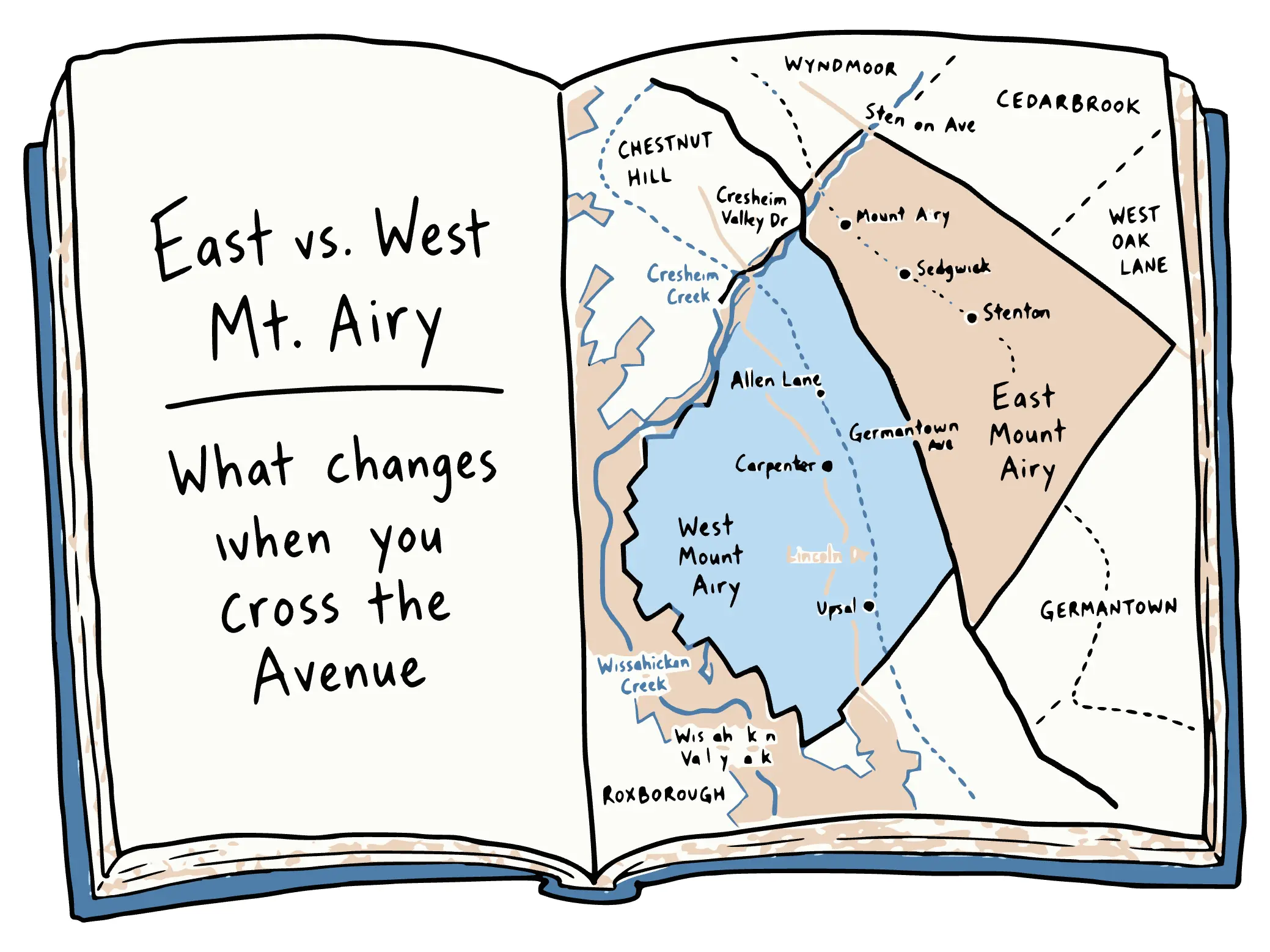
Germantown Avenue splits Mt. Airy into two halves, and the two halves have different houses at different prices. West of the Avenue, 29 percent of single-family homes are detached and the median assessed value is $495,100. East of the Avenue, 44 percent are rowhouses and the median assessed value is $285,900.
Both halves share the 19119 zip code, so nearly every published price for Mt. Airy is one median blended across both sides. That blended number describes neither side well. I built the map below to show where the line runs and what sits on each side of it, and the tables under it use the city's own property records for each half.
Which Side of the Avenue
Germantown Avenue is the line. Hover or tap either half to see what changes when you cross the Avenue.
Neighborhood boundaries from the OpenDataPhilly Philadelphia Neighborhoods dataset. Roads, rail lines, stations, creeks, the park and Wyndmoor from OpenStreetMap contributors, available under the ODbL. Housing counts, sizes and values come from the City of Philadelphia property assessment records, counting the single-family parcels in each half, July 2026. Assessed value is the city's figure rather than a sale price.
Where the line runs
The boundary between East and West Mt. Airy is Germantown Avenue itself. Everything southwest of the Avenue, down to the Wissahickon gorge, is West Mt. Airy. Everything northeast of it, out to Stenton Avenue, is East Mt. Airy. Cresheim Creek is the northern edge of the neighborhood, with Chestnut Hill beyond it. The southern edge, toward Germantown, is the one people disagree about: common usage puts it at Johnson Street, and both neighborhood associations put it at Washington Lane.
The Avenue is also the neighborhood's commercial strip, and it belongs to both sides. The shops, the restaurants, the 1928 Sedgwick Theater and the three blocks the city listed as the Central Mount Airy Commercial Historic District sit on the line. My guide to the Avenue covers the stops along it, and almost none of them belong to one half.
The houses on each side
In July 2026 I pulled every single-family parcel in each half from the City of Philadelphia's property assessment records:
| West Mt. Airy | East Mt. Airy | |
|---|---|---|
| Single-family homes | 3,627 | 5,903 |
| Median size | 1,968 sq ft | 1,504 sq ft |
| Median lot | 3,287 sq ft | 2,400 sq ft |
| Detached singles | 29% | 12% |
| Twins | 36% | 43% |
| Rowhouses | 25% | 44% |
Source: City of Philadelphia property assessment records, pulled July 2026. Every single-family parcel inside each half, counted against the OpenDataPhilly neighborhood boundaries drawn on the map above.
East Mt. Airy has about 2,300 more single-family homes than West Mt. Airy, and it's built more densely. West Mt. Airy has the neighborhood's largest houses: its detached houses run to a median of 3,450 square feet on a 13,256-square-foot lot.
The land explains part of the difference in lot sizes. West of the Avenue the ground drops toward the Wissahickon, so the streets wind and the lots run deep and irregular. East of the Avenue the grid is flat and regular all the way to Stenton Avenue.
The two halves were built in the same decades. Developers worked across the whole neighborhood from about 1880 to 1920, putting large houses on the big lots and twins and rows on the smaller ones, often within a few blocks of each other. West Mt. Airy has the 1890s Pelham development, with gray-stone Victorians in Cotswold and Norman styles. East Mt. Airy has the Gowen estate blocks from the 1880s and Sedgwick Farms, laid out around 1905 and sold as a suburb inside the city limits, which is where its Tudor revival houses come from.
House type also affects the roof, what the systems cost to run and what you can add later. I went through how the roofs vary across Northwest Philadelphia separately.
The prices on each side
The same kind of house is assessed lower on the east side. These are the medians by house type, with the size of the house and the lot next to the value:
| Median, by house type | West Mt. Airy | East Mt. Airy |
|---|---|---|
| Rowhouse | $373,700 · 1,360 sq ft on a 1,611 sq ft lot | $224,100 · 1,242 sq ft on a 1,480 sq ft lot |
| Twin | $511,100 · 2,188 sq ft on a 3,650 sq ft lot | $333,500 · 1,706 sq ft on a 3,184 sq ft lot |
| Detached single | $821,500 · 3,450 sq ft on a 13,256 sq ft lot | $560,500 · 2,464 sq ft on an 8,787 sq ft lot |
Source: City of Philadelphia property assessment records, pulled July 2026. Assessed value is the city's figure for tax purposes, not a sale price.
At the top of the market, size explains most of the gap. West Mt. Airy's detached houses are about 40 percent bigger than East Mt. Airy's, on lots about 50 percent bigger, and they're assessed about 47 percent higher. At the entry level, size explains much less. West rowhouses are about 10 percent bigger than east rowhouses, on lots about 9 percent bigger, and they're assessed about two-thirds higher. Across all single-family houses, the west side works out to $249 per square foot and the east side to $185.
Assessed values are the city's tax figures, not sale prices, and they lag the market. Recorded sales tell the same story. Deeds recorded since July 2025 show a west-side median of $543,000 across 95 sales. The east-side median was $290,000 across 129 sales, and more houses trade there because more houses are there.
The records don't capture condition, finish, renovation history or setting, and those vary house to house on both sides. Part of what west-side buyers pay for is the Wissahickon itself: the park frontage and the deep lots that come with building on a slope.
The trains
Each half has its own regional rail line into Center City, and the two lines were built by rival railroads.
West Mt. Airy is on the Chestnut Hill West Line, which SEPTA called the R8 from 1984 until it dropped the R-numbers in 2010. The Pennsylvania Railroad opened it on June 11, 1884, through a subsidiary called the Philadelphia, Germantown and Chestnut Hill Railroad, and ran it until 1976. Its trains ran into Suburban Station. The stops in Mt. Airy are Upsal, Carpenter and Allen Lane.
East Mt. Airy is on the Chestnut Hill East Line, the old R7. Its oldest section dates to 1832, built by the Philadelphia, Germantown and Norristown Railroad, and the Reading Company owned it from 1870 to 1976. Reading trains ran down the Reading Viaduct into Reading Terminal, a few blocks from the Pennsylvania's terminal. Its Mt. Airy stops are Mount Airy, Sedgwick and Stenton.
Both lines take roughly half an hour to Center City, on separate schedules. Bus routes cover both halves.
Neighborhood associations
Both halves have long-running neighborhood associations. West Mount Airy Neighbors was founded in 1959 and East Mount Airy Neighbors in December 1965, and both still operate. The Encyclopedia of Greater Philadelphia has entries on West Mt. Airy and Northwest Philadelphia for the longer history.
What usually decides it
Four things separate the two sides in practice.
House type and lot size. West Mt. Airy has a much larger share of detached houses on big lots, and the biggest houses in the neighborhood are there. East Mt. Airy is mostly twins and rowhouses on a tighter grid, across a wider range of sizes.
Inventory. East Mt. Airy has about 2,300 more single-family homes and more recorded sales, so there's usually more on the market and a deeper set of recent comparables to price against.
The Wissahickon. West Mt. Airy backs onto the park, and from much of it you can walk to Forbidden Drive or into the woods in a few minutes. From East Mt. Airy the same trailheads are a drive or a long walk.
The train. Chestnut Hill West on the west side, Chestnut Hill East on the east, both about half an hour into Center City on separate schedules.
My Mt. Airy neighborhood guide has the current market data for the neighborhood as a whole. I live in Mt. Airy, and I'm glad to walk either side with you. Reach out.
Henry is a Philadelphia-based REALTOR® serving buyers and sellers in Northwest Philadelphia and Montgomery County, PA. Questions? Get in touch.
Frequently asked questions
What is the difference between East and West Mt. Airy?
Germantown Avenue is the boundary. West Mt. Airy runs from the Avenue down to the Wissahickon gorge and holds 3,627 single-family homes with a median size of 1,968 square feet, a median lot of 3,287 square feet and a median assessed value of $495,100. East Mt. Airy runs from the Avenue out to Stenton Avenue and holds 5,903 single-family homes with a median size of 1,504 square feet, a median lot of 2,400 square feet and a median assessed value of $285,900. West has more detached houses on deeper lots, East has more rowhouses and twins on a tighter grid, and East is the larger half by roughly 2,300 homes.
Which street divides East and West Mt. Airy?
Germantown Avenue. The Avenue runs southeast to northwest through the neighborhood, and the boundary between the two halves follows the street almost exactly. Everything southwest of Germantown Avenue, down toward the Wissahickon Valley, is West Mt. Airy. Everything northeast of Germantown Avenue, out to Stenton Avenue, is East Mt. Airy. Both halves share the Avenue itself as their commercial spine, which is why the shops, restaurants and the Sedgwick Theater belong to the whole neighborhood rather than to one side.
Is West Mt. Airy more expensive than East Mt. Airy?
Yes. The median assessed value is $495,100 in West Mt. Airy against $285,900 in East Mt. Airy, and deeds recorded since July 2025 run to a median of $543,000 on the west side against $290,000 on the east. Much of that reflects what is being bought. Comparing the same house type, West Mt. Airy's detached homes are about 40 percent larger on lots about 50 percent bigger, which accounts for most of the difference at that end of the market. Toward the entry level the sizes converge while the values do not. Assessment records do not capture condition, finish or setting, which vary house to house on both sides.
Do East and West Mt. Airy have different train lines?
They do, and the split goes back to two rival railroads. West Mt. Airy is served by the Chestnut Hill West Line, designated the R8 from 1984 to 2010, which the Pennsylvania Railroad opened in 1884 and ran until 1976; its stops are Upsal, Carpenter and Allen Lane. East Mt. Airy is served by the Chestnut Hill East Line, the old R7, whose oldest section dates to 1832 and which belonged to the Reading Company from 1870 to 1976; its stops are Mount Airy, Sedgwick and Stenton. Both reach Center City in roughly half an hour, on separate schedules.
Which zip code covers East and West Mt. Airy?
Both halves sit in 19119, which is why most published market data treats Mt. Airy as one place and reports a single median for the whole neighborhood. That figure sits between two different markets and describes neither one well. Some of the area northeast of Stenton Avenue, past East Mt. Airy proper, falls into 19150 and is sometimes counted as Mt. Airy too.